Thursday, July 22, 2010

Dot Distribution Map


Dot Distribution Maps, also called Dot Density Maps, use small dots to represent some statistical data characteristic about a particular area. This map illustrates children ages 5-17 by census block for the northern New Castle County school Districts. One dot per 5 kids.

Propaganda Map


Propaganda maps are often used by the government, to influence the general public of a certain idea. They manipulate what might be real and shape it into something that will lead an individual to feel a certain way about the topic at hand. This map illustrates the Red Army's spreading influence over central Europe.

Hypsometric Map


A hypsometric map is a map giving elevations by contours, or sometimes by means of shading, tinting, or batching. This map is illustrating travel times from Cambridge to outlying areas or cities. Red is the fastest travel routes and blue is the slowest.

PLSS Map


A Public Land Survey Systems (PLSS) map is used by the United States government to divide areas of public domain. This was established in the Land Ordinance of 1785. The Land Ordinance of 1785 divided lands into 6 sqare mile townships. These divided sections can then be divided again in to sub-sections and so on.

Cadastral Map


A Cadastral Map is a map in which metes and bounds are used to establish property lines.  This is illustrated by defined areas usually portrayed with numbers signifying ownership or tenure. These can be residential, local, or national.

Wednesday, July 21, 2010

Thematic Map


This is a thematic map of the Paris region. This map shows where someone could find business parks, transportation, hotels, and economic centers. Thematic maps are maps that focus on illustrating specific ideas or themes.


Topographic Map


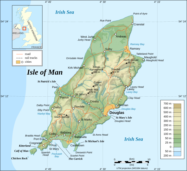
This is a topographic map of the Isle of Man. A topographic map uses contour lines to portray the shape and elevation of the land. Topographic maps capture 3-demensional aspects of terrain on two-dimensional surfaces.